Global maritime defence company Forcys is building on its recent merger with a keystone contract award. Reaffirming its focus on the defence sector, Forcys will deploy its Sentinel Intruder Detection System (IDS) across multiple sites for a close allied nation to protect vital elements of their Critical National Infrastructure (CNI).
In an ever-shifting sociopolitical landscape, the ability to counter unseen underwater threats grows more critical by the day. For over two decades, Sentinel has provided global peace of mind, becoming the world’s most deployed intruder detection sonar. The system detects, tracks, and classifies divers and uncrewed underwater vehicles (UUVs) approaching a protected asset from any direction, providing security teams with the early warning needed to react.
Paul Badger, CEO of Forcys, stated: “This contract demonstrates our enhanced capacity to deliver large-scale projects. By integrating our teams, we’ve matched world-class engineering and program management with global outreach. This synergy is exactly why we brought Forcys, Chelsea Technologies, and Wavefront Systems together.”
Ioseba Tena, CCO of Forcys, added: “Following a year of high-volume expeditionary deliveries providing ‘protection on the move’, 2026 sees Forcys scaling to meet the world’s most significant CNI challenges to deliver ‘protection that stays’. Our expanded team is now rolling out permanent IDS installations where permanent vigilance is the only option.”

Capable of identifying divers at ranges up to 1,000m and UUVs at 1,500m, Sentinel sets the standard for reliable, long-range underwater detection. It is currently utilized for defence, CNI, vessel, and VIP protection duties worldwide.
Forcys has been involved in numerous discussions related to Critical National Undersea Infrastructure (CNUI), which result in the conclusion that maritime naval forces and security organisations are being expected to reorient to the new task and are looking for technology to provide quick-win solutions for delivery. But how is this additional activity funded and delivered? How could industry support the protection of their assets, from which they make substantial profit?
The stark reality is that industry will only engage with the process when the operating risk becomes intolerable and/or the profitability of its business is not affected. To compel industry to pay for CNUI protection is not as simple as imposing a levy. A comprehensive approach that aligns financial incentives, regulatory frameworks, and collaboration between the private sector, governments, and naval forces is essential.
This article by Justin Hains, Business Development Manager, discusses the ‘top down’ approaches that could strengthen the security of CNUI and concludes with an initial step towards collective responsibility for security, irrespective of the countries involved.
Highlighting Financial Risks and Losses
Companies must recognize the significant financial risks of infrastructure failure, including disruptions from sabotage, natural disasters, or cyber attacks. Such incidents can lead to substantial downtime, revenue loss, and reputational damage. Potentially, investment in protection could lower insurance premiums, presenting a clear financial incentive to safeguard undersea infrastructure.
Public-Private Partnerships (PPPs)
Governments could encourage joint funding mechanisms, where both public and private sectors share the cost of protection. This could include subsidies or incentives for companies that invest in undersea security. A shared responsibility model motivates both sectors to contribute, minimizing the burden on individual entities.
Economic and Operational Benefits
Protection should be seen as a long-term investment. Preventing service interruptions and costly repairs reduces future expenditures, while avoiding fines for non-compliance or environmental damage. Secure infrastructure enhances reliability, operational efficiency, and could provide a competitive edge for companies prioritizing resilience.
Raising Awareness of Vulnerabilities
Increasing awareness about the growing risks—ranging from cyber attacks to physical sabotage—could spur companies into action. Sharing case studies of past incidents where undersea infrastructure was damaged can help highlight the serious consequences of neglecting protection.
Legislation and Regulation
Governments could implement mandatory security measures for critical infrastructure, with penalties for non-compliance. Additionally, tax incentives or credits can encourage voluntary investment in protection. A regulatory framework could ensure that companies take the necessary steps to safeguard their assets, viewing it as both a legal and financial obligation.
International Cooperation and IMO Framework
Under international law, the United Nations Convention on the Law of the Sea (UNCLOS) grants nations exclusive rights over the seafloor within their Exclusive Economic Zones (EEZs), where much of the critical infrastructure lies. The International Maritime Organization (IMO) provides a framework for the safety and security of maritime infrastructure. Governments can urge industry to cooperate in protecting these assets, noting that disruptions to infrastructure within the EEZ could have both national and international repercussions. Multinational agreements and IMO initiatives can help distribute the costs of protection.
Centralized Reporting and Monitoring Hub
A centralized hub would allow for real-time reporting, monitoring, and coordination among stakeholders. This system would integrate data from various sources—such as satellite surveillance, sensors on infrastructure, and environmental monitoring—to detect potential threats, enabling rapid responses, and inform stakeholders in a timely, accurate and coherent manner. The UK Maritime Trade Operations located in Dubai provides an example of such a response to piracy, armed robbery and potentially mining events, where the shipping industry and naval forces benefit from common situational awareness. A central platform for CNUI would allow quick incident reporting, ensuring coordinated responses from industry, government, and naval forces.
Data Sharing: Asset Location and Environmental Information
Companies should share location data of critical assets and environmental information. This allows authorities to better protect and respond to threats, especially in high-risk zones. Sharing environmental data (e.g., seismic activity or water currents) aids in preventing natural risks that could impact infrastructure. Additionally, sharing cyber security-related data helps protect against digital threats.
Legal and Regulatory Framework for Data Sharing
To encourage data sharing, clear legal frameworks must protect proprietary information while ensuring the sharing of necessary security and environmental data. Governments could offer liability protections for companies that share information in good faith, and establish data-sharing standards for consistency and security.
Conclusion
Key to the success of CNUI protection is the creation of a centralized reporting and monitoring hub, coupled with secure data sharing between industry, government, and naval forces. This could be the first step towards a holistic approach to protection of undersea infrastructure. Underpinned by international frameworks like UNCLOS and conforming to IMO guidelines, this approach offers stronger risk management, quicker response times, and greater resilience, ultimately encouraging industry to invest in the protection of critical infrastructure.
At Forcys, we understand that modern maritime security demands more than just sophisticated sensors or autonomous vehicles – it requires seamless integration of cutting-edge technology. This is where the combined expertise of our technology partners comes into play. The capabilities of EIVA’s ViperFish, alongside advanced solutions from Sonardyne, and Wavefront Systems are reshaping how subsea threats are monitored and managed, ensuring that the maritime defence community has the tools needed for effective real-time operations.
ViperFish is an all-in-one remotely operated towed vehicle (ROTV) designed for high-resolution data collection in autonomous operations. At Forcys we see the integration of this product as a significant step forward in autonomous operations. Designed for seabed imaging and geophysical surveys, ViperFish performs these tasks with remarkable precision, particularly and can even be paired with unmanned surface vessels (USVs). This opens up new possibilities for autonomous operations in complex underwater environments, enhancing mission safety, efficiency and data accuracy.
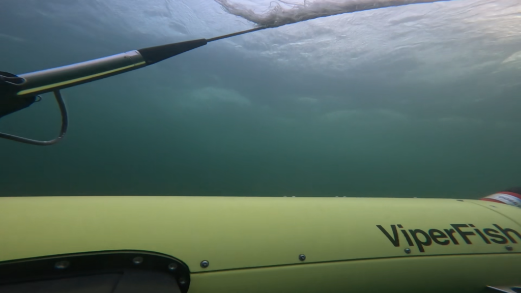
By combining this ROTV with positioning systems, sonar technology and EIVA’s NaviSuite survey software, we deliver a powerful, integrated solution that supports critical defence missions. ViperFish’s ability to automatically maintain a set height above the seabed makes it an invaluable tool for mine countermeasures, UXO (unexploded ordnance) surveys, and rapid environmental assessments.
“Forcys leverages Covelya Group partnerships to deliver solutions that provide capabilities beyond the sum of their individual components,” says Antonio Belfiore, Senior Sales Manager at Forcys. “Additionally, the combined research and development expertise across our group of companies enables Forcys to rapidly adapt to emerging threats and evolving mission requirements. This knowhow was instrumental in the development of ViperFish. Designed to be the tool of choice for mine-hunting across the littoral and in riverine environments, Viperfish is also easy to use and provides your team actionable data in real-time.”
In the context of mine warfare, these integrated solutions are revolutionising the way threat detection is carried out. By relying on autonomous vehicles that can navigate complex underwater environments with precision, defence teams can carry out missions more efficiently and frequently than ever before. The combination of ViperFish’s flexibility and the advanced sensor technologies it brings together enables vast subsea areas to be covered with unprecedented detail.
These advancements not only improve operational efficiency but also provide the necessary foundation for many future maritime and defence security operations.
At Forcys we’re proud to be part of this journey, ensuring that autonomous technology plays a central role in securing your assets.
Read more about our technology partner EIVA.
Discover ViperFish ROTV deployed by ProZero 8m Naval Intelligence USV: