Forcys brings together leading technologies, offering a comprehensive naval and subsea capability to the Australian defence market
Evolving threats, unlawful maritime claims, military coercion, all these factors are destabilising the Asia Pacific region and causing many lawful states to reconsider their defence strategies. Australia’s 2020 Defence Strategic Update and the anticipated March 2023 release of Australia’s Defence Strategic Review has brought these issues into sharp focus while demanding growing self-reliance for delivering deterrent effects. Today’s launch of Forcys Australia and the appointment of Sean Leydon as Regional Manager for Asia Pacific, is in direct support to this strategic need.
Backed by over fifty years of experience, Forcys offers the global maritime defence sector, remote, autonomous and networked control capabilities that deliver integrated situational awareness to customers in the underwater domain.
Covering a range of maritime operations including asset protection, littoral strike, mine warfare, submarine rescue, and submarine and anti-submarine warfare, Forcys seeks to transform the underwater domain by enabling increasingly distributed and automated operations. This is made possible by integrating and bringing to market world-changing solutions from leading technology partners Chelsea Technologies, EIVA, Sonardyne, Voyis and Wavefront Systems.
Commenting on the Australia launch, Ioseba Tena, Commercial Director of Forcys, said: ‘I am excited, Australia is taking bold decisions in the underwater domain. There’s been a realisation that uncrewed systems take a lot of the risk out of the conflict, they afford higher levels of attrition and deliver higher coverage rates. The sense of urgency is palpable and there is an appetite to work with industry experts to support the transition. We are keen to support a sovereign, sustainable capability.’
Sean Leydon, Regional Manager for Forcys’ Asia Pacific region, explains: ‘Our technology partners already engage with the Australian Government and industry, so our initial focus will be on improving those interactions by providing an in-country presence. However, our ambition doesn’t stop there, we are actively recruiting engineers to help support our existing customers and in time to develop sovereign capability. I’m looking forward to help make a difference.’ Forcys is exhibiting at the NAVDEX exhibition in the United Arab Emirates between 20th and 24th February 2023 at stand A-029. If you’d like to arrange a meeting with the Forcys team, please get in touch.

In Brief
In this project, the University of Tasmania evaluated the capabilities of optical-based sensors when using an AUV (Autonomous Underwater Vehicle) to dynamically survey large areas and identify specific objects of interest within environments. Based on the performance of the systems and the overall process, recommendations will be made to Defence Science and Technology for using this technique when trying to identify a mine-like object (MLO) underwater.
The challenge
Wide-area sensors, like sonar, can be used for mine detection, but don’t always offer enough details for the identification stage. Meaning that historically, underwater mine identification has been done by deploying divers or remotely operated vehicles.
The solution
Our technology partner, Voyis, develop high-resolution optical systems capable of rendering laser point cloud data and capturing 4k stills images. These provide a complete visual understanding of mine-like objects (MLOs), improving mission lethality, and reducing risk by limiting diver deployments in the minefield.
The Insight Pro laser scanner, the stills camera Observer Pro, and the Nova LED panel were bottom mounted in the University of Tasmania’s ISE Explorer AUV . All data was collected and saved to the onboard storage of the sensors; image data was processed in real-time. The AUV travelled at an altitude between 1.5-15m while the laser and stills system collected data, operating harmoniously to ensure laser and stills data sets of the same targets were collected.
The result
Voyis sensors were easily integrated into the Explorer AUV and generated crisp 4K images. The data collected provided enough details for the easy identification of objects, allowing users to distinguish between mines and similar objects found underwater.
The crisp stills images are enhanced in real time, for complete situational awareness in warfare operations. Images are corrected to remove all aspects of the water medium – colour, lighting, and distortions. The results provide a significant improvement in relation to conventional optical systems typically mounted on AUVs. From now AUVs can potentially be used to build wide area high-resolution maps of the subsea environment.

Contact us if you would like to reach out to our experts.
If you have to operate side-scan sonars and synthetic aperture sonars (SAS) in very shallow waters (VSW) or shallow waters (SW), the acoustic environment is particularly hostile. Higher order multi-path reverberation, unstable velocity of sound profiles, often unknown, as well as significant bathymetry, baseline decorrelation effects and generally far fewer stable platforms, all add up. The result is far less reliable end sonar products with greater impact to longer range systems. This is particularly acute in tidal and riverine environments. What to do?
Go back to the drawing board
When Solstice was developed in 2010, our technology partner Wavefront Systems decided it was time for a step up in the performance of traditional side-scan sonars. The aim was to deliver a high-frequency, high-resolution, and long-range sonar that would provide a marked improvement in the probability of detection of mine-like objects while minimising the probability of false alarms.
Solstice was designed to do just that. Step one was to design a multi-aperture array which would improve the signal-to-noise ratio extending the range over other sonars operating at the same frequency. However, longer ranges in shallow waters are susceptible to multi-path reverberation. Dr Rob Crook, Research Director at Wavefront Systems explains how Solstice overcomes this problem: “The dominant source of noise for all side-scan sonars operating in shallow waters is ‘multi-path’ reverberation. The nature of this noise means many acoustic pathways scattering from spatially unrelated regions of the underwater scene may none-the-less return to the sensor with identical flight-times. The inability of any ‘2D’ (range, bearing) sensor to discriminate between these contemporaneous pathways leads to an inevitable loss of contrast. Multi-path Suppression Array Technology (MSAT) is a physical array-based technology that offers the swathe coverage one would traditionally have associated with wide elevation beam-widths, with the shadow contrast associated with very narrow beams. MSAT allows high shadow contrast right out to the maximum range of the sensor whilst maintaining high quality imagery close to nadir.” Why is contrast important? It helps to differentiate targets from the surroundings.
In addition, Solstice implements dynamic focusing ensuring that the image will maintain the highest possible resolution at the position in space relative to the sensor, meaning that the resolution will improve as the range to the target decreases. While at longer ranges the interpolated real-time imagery drastically aids human visual perception.
What does it all mean?
The design choices lead to significant advantages for Solstice users. These are some examples of where Solstice excels.
- Simpler to operate: Solstice is simple, the area coverage rate increases with speed while the range remains constant. This makes mission planning easy. You can understand and use the constant range to plot a survey route and you can observe the area that is under consideration. The survey outcome becomes more predictable and simpler to manage.
- More robust: Systems like SAS are known to be very sensitive when mounted on an unstable platform or operating over complex seafloor environments. Any dynamic changes may impact the quality of the SAS data; mud sediments can result in complete loss of micro-navigation data, and in the worst outcome the SAS needs to revert to normal side-scan mode. SAS typically operates at a lower frequencies hence this corrupted SAS side-scan data is not suitable for most operations. Solstice MAS does not share this problem.
- High currents: In MAS the range is limited as a function of the so-called ‘crabbing angle’ but the image quality is preserved along the whole swath.
- Shallow waters: Operations in confined spaces and shallow waters (20m to 30 m depth) are difficult for SAS systems or lower frequency side-scans. These systems can become range limited as the multipath effects from surface returns has an impact on the SNR performance and this is common for all side-scan sonars. For some SAS systems, these effects can compromise as much as 50% of their swath but with Solstice MAS, the impact will typically be less than 10%.
![]() | ![]() | ![]() | ![]() |
22 m | 47 m | 72 m | 92 m |
Please contact us to find out more.
In brief
One person-portable remotely operated vehicle (ROV) systems are increasingly being counted on to deliver support to expeditionary forces conducting underwater operations. Used to inspect and to help deploy payloads at significant depths, combat and EOD divers can count on these ROVs to provide intelligence ahead of a dive. Now packed with automation features, new generation micro ROVs have become precise inspection tools.
The challenge
Your warfighters are increasingly being relied upon to deploy, operate, and maintain complex tools in support of their operations. Diving teams have it harder than most as they need to deploy these tools underwater against currents, with low visibility and poor positioning references.
The solution
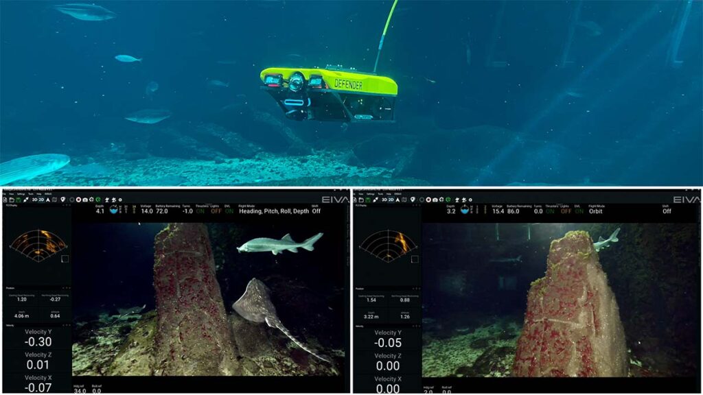
Developed by our technology partner EIVA, NaviSuite Mobula is a complete ROV software package with many advanced features for automatically and efficiently planning and performing ROV inspections, as well as enabling powerful data processing so operators can easily create high-quality, comprehensive data deliverables. Fully integrated from the factory with Defender ROVs from VideoRay, it provides your warfighters with a simple to use fly-by-wire control system. It delivers faster re-acquisitions and better data from which to make decisions.
The result
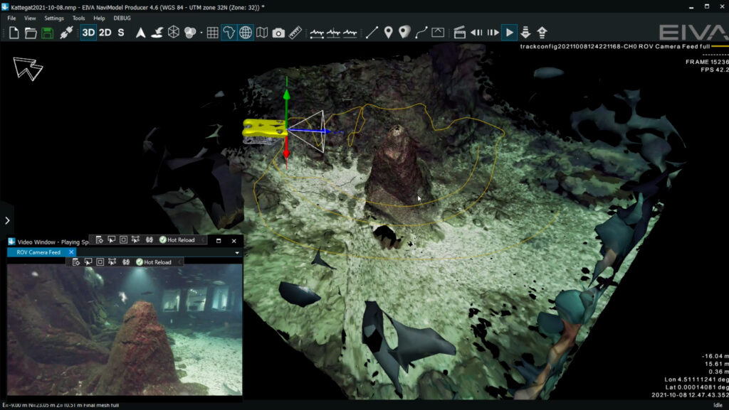
Combining NaviSuite Mobula with a micro ROV makes controlling the ROV a simple task. You can configure the user interface to suit your preferences. Flying the ROV is simple, simply drop a waypoint or select a set distance and direction and the ROV will automatically fly to that location. Use 2D, 3D and 4D model visualisations to improve your situational awareness. It’s also equipped with automatic sonar data cleaning and navigation processing tools that deliver improve your deliverables. In addition, it’s capable of generating fly-by videos or 3D visualisations to support your reporting and decision making. NaviSuite Mobula delivers actionable results enabling your warfighters to focus on information and not the process of acquiring it.

Forcys can enhance your experience with other innovative, advanced tools such as wireless acoustic initiation triggers, inertial navigation systems or optical systems from our technology partners at Sonardyne and Voyis. We can also support your autonomy programme with the integration of automatic target recognition using NaviSuite Deep Learning, or VSLAM computer vision, which lets you create 3D models using a single camera.

NaviSuite Mobula supports Defender ROV users, but it you would like to consider this innovative system to enhance a different platform please contact us.
We look forward to helping you with your requirement.