An interview with Dr. Rob Crook, Research Director, Sonar Systems here at Forcys.
Solstice Multi-Aperture Sonar, or as we call it, Solstice MAS is a product of a rethink of side scan technology from the bottom up.
It aims to blend the high resolution of Synthetic Aperture Sonar (SAS) with the robustness and the reliability of side scan. The high-quality imagery is dependent on more than just high resolution. Solstice is therefore designed to provide not just high resolution but high SNR and contrast too. To achieve this, Solstice is built around five key technologies. In this interview, we’ll concentrate on Multi Ping Multi Look (MPML) and how this distinguishes Solstice MAS from SAS.
Q. Before we look at Solstice MAS and its advantages over traditional sidescan and synthetic aperture sonar systems, could you please briefly explain what these two actually are?
Sidescan sonar dates back to the 1970s and it’s become a workhorse technology used for commercial surveys or for search, classification, and mapping type MCM operations. It creates useful imagery of the seabed and objects which lie on it.
The longer the array of hydrophones or aperture used by the sidescan sonar, the better the picture resolution. Higher operating frequencies create higher resolution imagery, but that’s at the expense of range. Synthetic aperture sonar, or SAS, seeks to improve this resolution by synthesizing an aperture in the signal processing far longer than the actual physical sonar array. Also, SAS tends to operate at a considerably lower frequency, which helps extend its range.
Q. What experience do Forcys have in this technology?
Our engineers at Forcys have considerable experience in designing and developing synthetic aperture sonar systems. Two of our principal designers led the hardware development for NATO’s so-called MUSCLE SAS program and also led the development of a SAS system for a major international defense company.
Forcys, through Wavefront Systems, acted in a design consultancy role for several other SAS projects over the past decade. From this experience, we’ve learned that SAS can be very effective, but it is not without its drawbacks. It’s relatively expensive, heavy, and power-hungry, and in some fairly commonplace scenarios, SAS can be fragile.
Q. What do you mean when you say SAS can be fragile?
SAS can produce impressive results in the right conditions, such as deeper deployments away from the surface effects or when deployed on larger, more stable platforms. However, SAS can struggle in very shallow water—less than 40 feet deep—or when deployed on smaller, say 9 or 12-inch diameter AUVs. In these situations, feedback from users suggests SAS performance can degrade significantly.
Q. And what would that degradation look like and why does it occur?
Some SAS systems can compromise as much as 50% of their claimed swath in shallow water, or default to the poor resolution associated with its real aperture length when the coherent processing fails. The quality of this data is rarely of operational use and missions have been compromised as a result.
As to the why: SAS performance is adversely affected by higher-order multipath interference commonly encountered in shallow water scenarios. Its performance is degraded by unknown or dynamic sound velocity profiles. It demands high-accuracy bathymetry, without which non-linear platform trajectories will not produce focused images, and it struggles to provide reliable performance, particularly in high cross-currents, due to the impact these have on the SAS micro-navigation.
Now, some of these issues aren’t unique to SAS, of course, but because SAS seeks to extend the range of conventional sidescan sonar, they have a far greater significance for SAS.
Q. And what are the associated operational issues with SAS?
Large, heavy, power-hungry systems; complex mission planning due to its achievable range being dependent upon its speed—with higher speeds reducing available ranges—and often unmanageable quantities of real-time data making real-time processing problematic.
Q. Okay, so tell us, what did you do?
We decided to completely rethink the sidescan tech from the bottom up with the aim of developing a sensor which blended the high resolution of SAS with the robustness and reliability of sidescan.
Q. So, tell us more about Solstice.
Well, high-quality imagery is dependent on more than just high resolution. Solstice is therefore designed to provide not just high-res, but high SNR (signal-to-noise ratio) and contrast. To achieve this, we designed Solstice around five key technologies: MSAT (Multipath Suppression Array Technology), RAC (Real-time Auto Calibration), Motion Compensation, Pixel Perfect Imaging, and last but certainly not least, multi-ping multi-look.

Q. Is this last core technology the one that most clearly distinguishes MAS from SAS?
Yes, it’s what makes MAS unique and distinct from SAS for sure. Our multi-ping multi-look tech incoherently combines returns from multiple pings to greatly enhance the image signal-to-noise ratio, which in turn greatly reduces the distracting speckle-type noise so common in SAS imagery.
This ability to integrate incoherently allows our multi-aperture processing to be far less affected by navigational inaccuracies. This makes Solstice’s imaging performance in shallow water environments on smaller, less stable vehicles far more robust.
Of course, design decisions like this come with trade-offs. In this case, incoherent multi-aperture processing doesn’t increase the image resolution as the multiple apertures are processed, but MAS largely offsets this effect by using a much higher operating frequency than a typical SAS. Its natural real aperture resolution is therefore much better—a better starting point, you might say.
Q. Just to be clear, can you explain precisely what you mean by coherent and incoherent processing, and how are they different?
So, SAS coherent processing uses both the signal phase and amplitude information. Multi-ping multi-look uses incoherent processing, meaning only the amplitude is used for processing of the multiple apertures.
Q. Now what are the operational advantages of Solstice MAS?
Solstice has the ability to image large areas of the seabed at significantly higher ground speeds than SAS. Its low 20-watt power draw dramatically extends search, classify, map mission durations for AUVs, and this allows the sonar to be used alongside identification systems such as Voyis’s laser line scan in our latest L3Harris IVER4 Recon module.
Mission planning is simplified due to the constant range swath, and that all the advanced MAS processing can be performed on board the vehicle itself in real time, producing manageable quantities of data that are available for third-party software packages such as automated target recognition algorithms.
Q. Are you continuing to develop Solstice and can you share any future developments?
We pride ourselves on maintaining relationships with our end customers, listening to their real-world experiences of sensor tech, and using this information to help guide our development and improve our products.
The latest addition to the Solstice family is a bigger brother, Solstice MAS 4000. It’s now being sea trialled and has already achieved SAS-like along-track resolution within a power budget of just 24 watts.

At Forcys, we understand that modern maritime security demands more than just sophisticated sensors or autonomous vehicles – it requires seamless integration of cutting-edge technology. This is where the combined expertise of our technology partners comes into play. The capabilities of EIVA’s ViperFish, alongside advanced solutions from Sonardyne, and Wavefront Systems are reshaping how subsea threats are monitored and managed, ensuring that the maritime defence community has the tools needed for effective real-time operations.
ViperFish is an all-in-one remotely operated towed vehicle (ROTV) designed for high-resolution data collection in autonomous operations. At Forcys we see the integration of this product as a significant step forward in autonomous operations. Designed for seabed imaging and geophysical surveys, ViperFish performs these tasks with remarkable precision, particularly and can even be paired with unmanned surface vessels (USVs). This opens up new possibilities for autonomous operations in complex underwater environments, enhancing mission safety, efficiency and data accuracy.
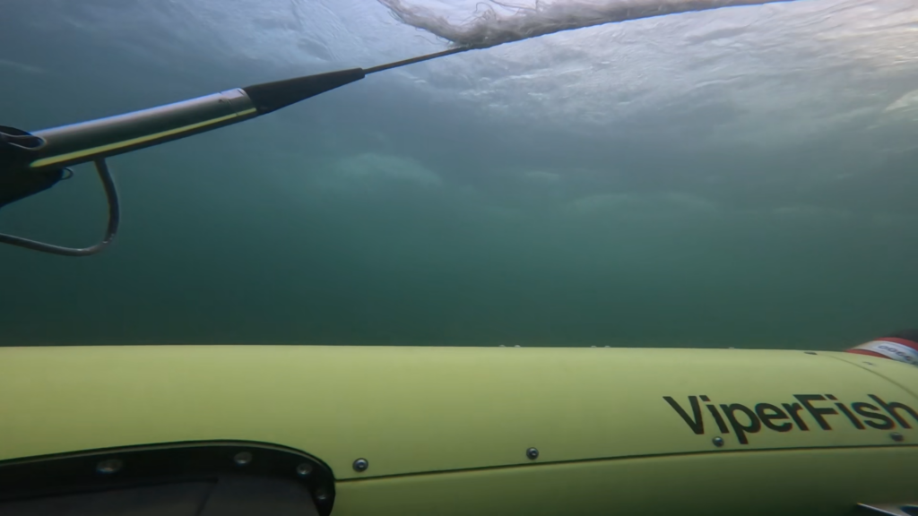
By combining this ROTV with positioning systems, sonar technology and EIVA’s NaviSuite survey software, we deliver a powerful, integrated solution that supports critical defence missions. ViperFish’s ability to automatically maintain a set height above the seabed makes it an invaluable tool for mine countermeasures, UXO (unexploded ordnance) surveys, and rapid environmental assessments.
“Forcys leverages Covelya Group partnerships to deliver solutions that provide capabilities beyond the sum of their individual components,” says Antonio Belfiore, Senior Sales Manager at Forcys. “Additionally, the combined research and development expertise across our group of companies enables Forcys to rapidly adapt to emerging threats and evolving mission requirements. This knowhow was instrumental in the development of ViperFish. Designed to be the tool of choice for mine-hunting across the littoral and in riverine environments, Viperfish is also easy to use and provides your team actionable data in real-time.”
In the context of mine warfare, these integrated solutions are revolutionising the way threat detection is carried out. By relying on autonomous vehicles that can navigate complex underwater environments with precision, defence teams can carry out missions more efficiently and frequently than ever before. The combination of ViperFish’s flexibility and the advanced sensor technologies it brings together enables vast subsea areas to be covered with unprecedented detail.
These advancements not only improve operational efficiency but also provide the necessary foundation for many future maritime and defence security operations.
At Forcys we’re proud to be part of this journey, ensuring that autonomous technology plays a central role in securing your assets.
Read more about our technology partner EIVA.
Discover ViperFish ROTV deployed by ProZero 8m Naval Intelligence USV:
Explosive ordnance, such as mines, pose a significant threat to naval operations, offshore energy projects, and other maritime activities. Traditional methods of disposing of these hazards often put personnel and equipment at risk as they require divers or remotely operated vehicles (ROVs) to approach the ordnance closely and manually initiate the detonation process.
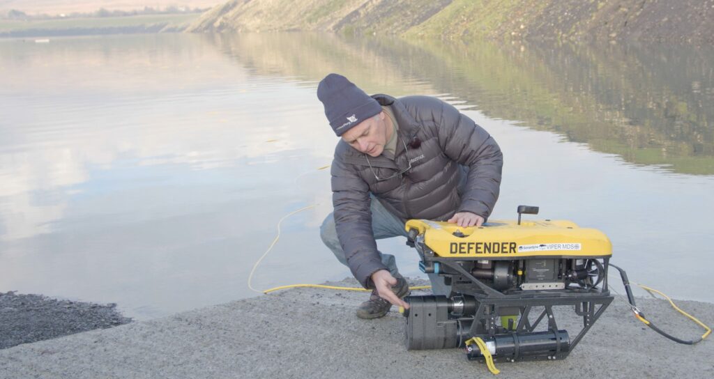
The Initiation Transponder 6 (IT 6) from our technology partner Sonardyne, when integrated with mine neutralisation devices mounted on a VideoRay Mission Specialist Defender underwater robot, provides a remote, autonomous, safe and effective solution for mine clearance operations. This technical collaboration allows for acoustic initiation and detonation from a remote location, eliminating the need for and risks associated with physical proximity to the ordnance.
The integration of the Defender and mine neutralisation devices with the IT 6 represents a significant advancement in the field of explosive ordnance disposal (EOD).
How it works:
- The IT 6 is connected to a non-electric mine neutralisation device, which is deployed near the contact by the Defender.
- Once the neutralisation device is in place, the Defender can be manoeuvred to a safe distance, typically around 1 kilometre away.
- Using Sonardyne’s Wideband 2 digital signal technology, the IT 6 receives an acoustic command to arm the charge from a surface vessel or command centre. A subsequent command then initiates the shock tube and detonates the neutralisation device.
- The entire process can be carried out in most weather conditions and during day or night, enhancing operational flexibility and safety.
Benefits:
- Enhanced safety: By eliminating the need for physical proximity to the contact during detonation, the combination of the IT 6 and Defender significantly reduces the risk to personnel and assets.
- Increased operational efficiency: The autonomous delivery and wireless initiation capability streamlines the process, allowing for faster and more efficient mine clearance operations.
- Versatility: The IT 6 and Defender can be used in various underwater environments, including deep-water operations, making it suitable for a wide range of clearance missions. The underwater robot is designed for more precise control of the vehicle position and orientation, heavier payloads and demanding interventions. With seven thrusters, it can move in any direction and maintain active pitch to face its target in an upward or downward orientation.
- Proven technology: Sonardyne’s Wideband 2 digital signal technology draws on a fifty-year heritage; it is field-proven, ensuring reliable and long-range underwater wireless communication. The Defender draws on VideoRay’s twenty-five years of ROV design experience and is built with power, reliability and flexibility in mind.
- Multi-shot: the IT 6 can be fired multiple times, making deck tests and practice runs affordable. In addition, if a mission is aborted the kit can be safely recovered and reused. The explosive charge and the IT 6 are only sacrificed on confirmed contacts.
- Cost: Once the initial investment has been made for the technology, the cost per deployment is significantly lower than sending personnel on each mission. If multiple ROVs are deployed, they can be controlled from one vessel or control room, thus further reducing costs.
Demonstration
In 2022, the IT 6 and the Defender were demonstrated together for the first time to the UK’s Defence Science and Technology Laboratory (DSTL) and the UAE Navy at a quarry in Wales.
The demonstration included successful detonations of a mine neutralisation device, delivered by the Defender and initiated by the IT 6, from a range of approximately 1 kilometre.
As armed forces around the world move towards more autonomous operations on land, in the air and under the sea, there will be increased demand for the utilisation of existing and the development of new technology.
The benefits in terms of safety, efficiency, adaptability and cost are obvious, not just in mine countermeasures; and the collaboration between market leaders, such as Forcys, Sonardyne and VideoRay, will be at the forefront of driving advances in the technology. Contact us to see how we can help you be there too.
_______________________________
Did you know that another of our technology partners, Voyis, manufacture the market’s technically leading ROV piloting camera? The Discovery camera from Voyis enhances your identification by delivering crisp 4K images of your targets in real-time. The ideal complement to the IT 6 and Defender. Find out more in a blog coming soon…
In this blog retired Royal Navy Cdr Justin Hains MBE provides a personal view on the challenges he faced as a serving officer in charge of diving. These are common challenges faced by many dive supervisors and until recently there was not much that could be done to mitigate for them. Read on to discover how our technology partner Sonardyne‘s new DiveTrack product line will make diving more effective and safer.
It wasn’t that long ago
I remember sitting in a dive boat at night, wondering if my unmarked divers would arrive safely at the pick-up point off Portland. The issue was lack of through water communications, so I was constantly running the “what ifs”. What if the divers didn’t surface in the place and at the time planned? If I wanted to recall them: how would I know my message would reach them? My rescue diver had no realistic chance of finding a casualty underwater. Without an external clue the odds were worse than 400:1.
I needed better situational awareness delivered by three broad requirements: me knowing the location of the divers; me communicating with the divers and the divers being able to communicate with me. Finally, underpinning all of this, in a worst-case scenario, I also wanted to send the rescue diver directly to a casualty without potentially fruitless and time-consuming underwater searches.
The technology that was missing all those years ago was reliable diver tracking and through water communications. Early solutions struggled with background noise and distortion, were limited to voice communications, and while solving the communications problem over reasonable distances did not provide accurate positional information to both diver and rescue boat.
Our technology partner Sonardyne’s DiveTrack provides a reliable answer to these core requirements with headroom for additional data exchange requirements in future. It is compact, neutrally buoyant in sea water, easy to use and reliable. It has been integrated with rebreathers and open circuit equipment. This is proven technology with application across all military diving from the experts in underwater acoustic tracking and communications.
The system has a low probability of intercept, and its encryption keeps transmissions secure. While there is a small chance of detection by a smaller group of adversaries the tactical advantage of having clear communications outweighs the small risk of real-time detection and exploitation.
Want to know more?
Follow this link to read my next blog on this subject, where I will discuss how DiveTrack provides safety, operational advantage and a greater probability of mission success. The combination of improved situational awareness, even in a GPS denied environment, and the reliability of communications and positioning provide an unprecedented level of tactical flexibility in a range of operational scenarios. The risk of detection and exploitation of the encrypted signals is easily outweighed by the operational advantages of the system. Finally, should the worse happen and a diver requires assistance: the rescue diver or other divers nearby can home onto the position. The rescue diver will find the casualty.
In brief
Just because your expeditionary forces operate small Autonomous underwater vehicle (AUV) systems, it doesn’t mean they should not be ambitious as to which payloads to carry. When deploying from a Rhib or other confined spaces, then low-logistic one-person operated instruments are a necessity. This requirement has seen the proliferation of small AUVs. In January of 2022 a number of this units manufactured by OceanScan-MST were delivered to Denmark’s Frederikshavn naval base. Though the AUVs are small, their payload requirements weren’t.
The challenge
The customer wanted to equip these AUVs with the latest generation of 4K digital stills cameras and 3D lasers. Fitting the equipment to an AUV already packed with sonar payloads and other navigation instruments is challenging. Fortunately our technology partner Voyis and their next generation optical systems were at hand. They had to work closely with OceanScan-MST to understand the constrains and develop the right mechanical design to integrate the popular Recon LS System.
The solution
The solution was to develop an OEM version of the Recon LS where each of the components was delivered and carefully integrated to the AUV. The integration to the platform is of paramount importance as the product has been very carefully designed to optimally illuminate the scene.
The result
The Light Autonomous Underwater Vehicle (LAUV) supplied by OceanScan-MST were equipped with an identification capability enabling each of the AUVs to search for contacts with the combined sonar and laser pair and enabling re-acquisition with the same AUV. This means improved probability of detections, increased area-coverage-rates and mission tempo and imaging with an amazing fidelity to support other missions beyond mine countermeasures.
If you would like to know how Forcys and its technology partners can support your expeditionary needs please do not hesitate to get in touch.